For listing agents · 8K + LiDAR capture

Retire the photo shoot.
Splat the listing.

One capture replaces your photographer and drone pilot — and delivers what they never could: an 8K photoreal 3D twin buyers can walk through, plus stills, drone aerials, and a LiDAR-accurate floor plan. Every asset your listing needs, from a single visit.

Trusted by agents replacing $1,000 photo packages with a listing asset buyers remember.
Photoreal Gaussian splat of a full home interior
Real 3D Gaussian splat — streams live in your browser
8K · 33 MP frames
LiDAR · ±1 cm

Demo scene: "Home Scan" by Isaiah Sweeney (@luxury_scans), CC BY 4.0 — shown to demonstrate splat technology. Your listing gets the full 8K + LiDAR treatment.

8K native capture resolution
LiDAR true-scale measurement
<48 hrs capture to delivery
1 visit replaces the entire shoot
One capture · Every asset

Everything your listing needs.
Nothing your photographer delivers.

Your media package isn't photos or 3D — it's both, from the same capture, perfectly consistent.

The 3D twin

A photoreal Gaussian splat buyers explore freely — every room, in true light, from any angle. Embed it on the MLS, your site, and social. The listing asset no photo package can match.

8K still gallery

MLS-ready hero shots pulled from the splat — reframe any composition, any time, without a re-shoot.

Drone aerials

An aerial pass on every capture — roofline, lot, and neighborhood context, woven into the same 3D model.

Listing-ready data

Square footage, room dimensions, and RESO-formatted property fields extracted from the scan — ready for your MLS entry.

LiDAR floor plan

Dimensioned 2D plan and room measurements accurate to ±1 cm — generated automatically, ready to attach.

Never re-shoot

New angle for a price drop? Twilight look for a relaunch? Render it from the twin — the property is captured forever.

See it to believe it

Don't take our word for it. Walk through one.

These are real Gaussian splats streaming live in your browser — no app, no download. Click and explore like a buyer would.

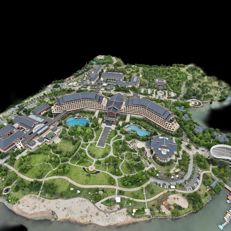
Aerial Gaussian splat of a resort property captured by drone

The aerial view

A full property captured by drone and reconstructed as one explorable model — roofline, grounds, and approach.

Demo scene: "Resort Hotel – DJI M3E" by ethan3111, CC BY 4.0

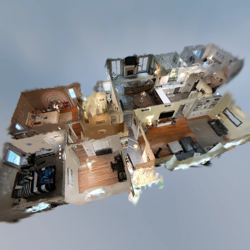
Gaussian splat of a complete home interior, dollhouse view

The full interior

An entire home, every room connected, explorable freely — the dollhouse view photography can't offer.

Demo scene: "Home Scan" by Isaiah Sweeney (@luxury_scans), CC BY 4.0

Community captures shown under Creative Commons to demonstrate the technology. GausHaus listings are captured with our proprietary 8K + LiDAR system — sharper, truer, measurable.

"Buyers don't fall in love with photos anymore. They fall in love with being there. GausHaus puts them there before the first showing."
— The GausHaus principle
How it works

One scan. We deliver everything.
Ready before you list.

One visit, three capture systems — spatial camera, drone, and professional stills — one complete media kit. We handle everything heavy on our own GPU servers; you never touch a camera.

STEP 01

We capture everything

A GausHaus capture specialist walks the property with our proprietary spatial camera — 8K imagery and LiDAR depth in one continuous pass — while our aerial unit flies the roofline and professional stills round out the kit. You don't lift a finger; sellers barely notice we're there.

STEP 02

GPUs rebuild reality

Our pipeline fuses 8K frames with LiDAR geometry and trains a full-resolution 3D Gaussian Splat on dedicated GPU servers — photoreal down to the grain in the countertops.

STEP 03

Your listing goes live

Within 48 hours: the interactive 3D twin, 8K stills, floor plan, and listing data — one link and a media kit, ready for MLS, your site, and social. The twin arrives ready to measure, stage, and tour.

The tech

Why Gaussian splatting beats everything else.

Photos flatten. Video constrains. Bubble tours teleport. A Gaussian splat — built from 8K ground imagery, drone aerials, and LiDAR depth — is a true, freely-explorable 3D reconstruction with photographic fidelity.

◆ 8K photoreal fidelity

View-dependent lighting, reflections, and fine detail — trim, fixtures, even signage text survives.

◆ LiDAR-true scale

LiDAR depth locks the model to real-world scale. Measure any distance with a click, to ±1 cm.

◆ Auto floor plans

Walls and floors are detected from LiDAR geometry to generate a dimensioned 2D plan automatically.

◆ Streams anywhere

Compressed .ksplat streaming puts the full model in any browser — desktop, tablet, phone.

◆ Export everything

PLY, OBJ, and glTF geometry plus measurement JSON and floor-plan SVG. Your data, portable.

◆ Private by default

Models are shared via expiring links only. Raw capture frames auto-purge after reconstruction.

Inside the twin

Your twin isn't a file. It's a workspace.

Every GausHaus model is delivered on our hosted platform — so you, your sellers, and your buyers can do far more than look around.

◆ Measure anything

Click two points for a ±1 cm distance — or trace a floor, wall, or countertop for true areas. No return visit, no tape measure.

◆ Stage it virtually

AI staging refits empty rooms with furniture and finishes — photoreal, true to scale, in the actual light of the space.

◆ Guided walkthroughs

A curated path tells the story you want — kitchen, primary suite, the view — while buyers stay free to wander off it.

◆ Pin notes & files

Annotations and documents attach to exact spots in the model — disclosures, spec sheets, inspection notes, punch lists.

◆ Compare over time

Multiple captures of the same property line up on a timeline — renovations, build progress, before and after.

◆ Embed & VR

Drop the twin into the MLS, your site, or social — and buyers with a headset can walk it at full scale in VR.

The capture stack

Air + ground.
One seamless model.

Most media packages bolt a drone clip onto a photo gallery. We fuse them: our enterprise aerial unit maps the roofline, lot, and approach while our spatial camera covers every interior — and both feed the same reconstruction.

Aerial unitEnterprise-grade drone, FAA Part 107 piloted — roof, lot, and neighborhood context on every capture.
Spatial cameraOur proprietary ground rig — 8K multi-sensor imagery fused with LiDAR depth, engineered for splatting.
Professional stillsMagazine-grade still photography on the same visit — color-matched to the model, MLS-ready.
GPU reconstructionDedicated servers train a full-resolution Gaussian splat from every frame, air and ground together.
Pricing

Priced by the size of your property.

Every package includes on-site 8K + LiDAR capture, a drone aerial pass, GPU reconstruction, a hosted interactive 3D twin, and your full listing media kit. Lot coverage up to ¼ acre included.

Price your property

Slide to your size for an instant quote — the same engine prices your booking.

Additional sites — photos onlyGuest house, ADU, barn · $99 per site 0
Additional sites — full 3D scan30 min included · $199 per site 0
Your instant quote
$699
Book this quote →
Same rates as booking — enter your address there and we pre-fill the details from public records.

Example: a 2,800 sqft home on a ¼-acre lot = $699 + $297 (structure) = $996. Commercial and multi-parcel are priced per project.

Please note: some common areas (shared condo/HOA amenities, gated community facilities, and other spaces we don't have authorization to capture) cannot be scanned.

Free cancellation until 24 hours before your shoot. Cancellations within 24 hours incur 50% of the quoted fee. Full terms.

Beyond listings

One technology. Every property story.

The same 8K + LiDAR splatting stack that sells homes documents job sites, markets commercial space, powers insurance records, and previews retail redesigns.

Construction

Document every build — from one room to an entire plant.

A kitchen or bath remodel, a custom home, a tenant improvement, or a large-scale industrial facility — we capture a photoreal, measurable 3D record of your project at any stage.

  • Scan before drywall — a permanent record of what's behind every wall
  • Progress documentation clients and lenders walk through remotely
  • ±1 cm as-built measurements for planning and verification
  • Dispute and insurance protection — the site as it actually was
  • Marketing-grade media for builders and remodelers
Splatting for construction →
Commercial

Lease it, manage it, market it — in true 3D.

Office, retail, industrial, hospitality, multifamily. Let tenants, investors, and buyers walk the space from anywhere — and give your facilities team a measurable digital twin.

  • Remote walkthroughs that pre-qualify tenants and buyers
  • Fit-out and space planning on ±1 cm accurate geometry
  • Facility documentation for operations and maintenance
  • Priced per project — every commercial property is different
Inquire about your property →
Insurance

Proof, not photos — for insurers and insureds.

For carriers and adjusters: photoreal, measurable inspection scans without repeat site visits. For property owners: document the property and its contents before anything happens — and preserve the scene after it does.

  • Underwriting and claims inspections reviewed remotely
  • Pre-loss documentation of condition and contents
  • Timestamped post-loss capture that preserves the scene
  • ±1 cm measurements pulled straight from the model
Splatting for insurance →
Retail

See the redesign before you build it.

Stores, showrooms, restaurants. Capture the space once — then click to see changes: new floors, counters, walls, fixtures, or a full redesign, rendered realistically on centimeter-accurate geometry.

  • Click-to-compare redesigns — floors, counters, walls, layouts
  • Photoreal renderings on ±1 cm true-scale geometry
  • Millwork and fixtures that fit the first time
  • Virtual visits and marketing for flagship spaces
Splatting for retail →
Book a Splat

Enter your address. We'll handle the rest.

We pull your property's lot and dwelling size, price it instantly, and get you on the calendar.

1 · Property
2 · Package
3 · Schedule
4 · Checkout

Where's the property?

Enter the full address and we'll look up the lot size and dwelling square footage.

Please enter a street address including city and state.
Property details

Your package

Pick your capture slot

Golden-hour slots make exteriors shine. We'll confirm your on-site window with your booking.

Please select a date and time.

Review & checkout

Confirm your details — you'll receive a confirmation and calendar invite by email.

Please fill in your name, a valid email, and a 10-digit phone number.
Please agree to the Terms & Conditions to continue.

No payment due today — we confirm every booking personally. Free cancellation until 24 hours before your shoot; cancellations within 24 hours incur 50% of the quoted fee.
By booking, you agree to our Terms & Conditions and Privacy Policy.

🏠✨

Scan Requested

Book another property
FAQ

Questions, answered.

What exactly is a Gaussian splat?

3D Gaussian Splatting is a state-of-the-art reconstruction technique that represents a scene as millions of tiny, view-dependent color "gaussians." The result looks like photography — because it's built from photography — but you can move through it freely in 3D, unlike a video or a bubble-to-bubble virtual tour.

What do you capture with?

Three systems, one visit: our proprietary spatial camera (8K multi-sensor imagery fused with LiDAR depth, engineered specifically for Gaussian splatting), an enterprise-grade drone flown by an FAA Part 107 certified pilot, and professional still photography. We keep the exact hardware stack to ourselves — the results speak for themselves.

Are there areas you can't scan?

Yes — some common areas cannot be scanned. Shared condo and HOA amenities, gated community facilities, and any space we don't have authorization to enter are excluded from capture. We scan the property you own or list, plus any additional sites you add to your booking.

Is the drone flight really included?

Yes — every package includes an aerial pass flown by an FAA Part 107 certified pilot with our enterprise-grade drone. Roofline, lot, and neighborhood context are captured on every visit and fused directly into your 3D model, not delivered as a separate clip.

Does this really replace my listing photographer?

Yes — that's the point. One GausHaus visit produces your 8K still gallery, floor plan, listing data, and the interactive 3D twin. Every asset comes from the same capture, so your marketing is perfectly consistent — and if you ever need a new angle, we render it from the model instead of re-shooting.

How long does capture take?

On-site time depends on the size and complexity of the property — we confirm your capture window when we confirm your booking. Large estates and acreage can take up to a half day. Your interactive model is typically delivered within 48 hours — delivery timing can vary with GPU processing availability.

How accurate are the measurements?

Our LiDAR capture locks the model to true metric scale. Point-to-point measurements are typically accurate to within ±1 cm indoors.

Can I use the model and media however I want?

Your package includes a full marketing license: exportable geometry (PLY/OBJ/glTF), your floor plan, measurement data, and every media asset — for the listing, your portfolio, and your own promotion. Hosting on our streaming viewer is included free for the life of your listing. Full license details are in our Terms.

Can you stage an empty listing?

Yes — virtual staging happens inside the twin. AI-assisted staging refits empty rooms with furniture and finishes, rendered photorealistically in the room's actual light. Because the model is true-scale, everything fits the way it would in real life — and you can offer buyers both the staged and unstaged views.

What can buyers do inside the 3D twin?

Walk freely or follow your guided tour, measure any distance or area to ±1 cm, open notes and documents pinned in the space, and — with a headset — explore the property at full scale in VR. The twin streams in any browser, no app or download required.

Do I need to prep the property?

Prep it like a listing photo shoot: lights on, blinds open, clutter away. Whatever our camera sees is what the model shows — in full 3D.